Info: The Perch River Dam area is very interesting, if you like trails as well as wildlife or/and fishing. There are some trails here and there, this is on DEC property.
Directions/Location:
This
comes in two parts. You can visit either or both sides of the dam area.
--To visit the northern side get on Route 12 (Bradley Street Road) heading
northward from Watertown, you will pass under the Route 81 overpass. Head out for around 6.6 miles
from this point and you will eventually come to a low area with a parking area
and marshlands. Continue past this a short distance and you will find the Vaadi Road on the right, travel down
the Vaadi road about .8 miles.
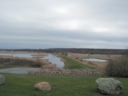
You will be at the top of a hill and be able to look out over the Perch River
Dam area and marsh.
At this location, near the top of the hill, you can take a right and go into a small parking area
that overlooks the dam on the right.
If you continue past this parking area a few feet look to the left, and there will be a
small sign that denotes the beginning of a trail heading into the woods.
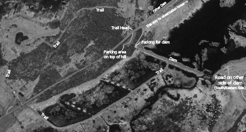
Click here for a map-
Map.
If you go a little further past the parking area, look to your right again and there is another
small dirt road near the foot of the hill. This will take you to the parking area for one
of the dams (that you can see from the parking area on top of the hill).
Click here for a map -
Map. You can walk across
the top of this dirt dam, as well as fish from it. Walk halfway down the
dam and you will find a trail on the right.
Watch for the geese (and their droppings!).
If you continue down the Vaadi Road you will pass the other dam on the
left (which you can also walk on), another
small parking place, and a couple small bridges where people fish. About a mile
up the Vaadi Road from the trail and dam, you will come to a look-out area with a tall tower and
short path leading to it. Here's a map -
Map.
--To visit the southern side of the dam get on Route 12 (Bradley Street Road) heading northward from Watertown, you will pass under the Route 81 overpass. From this point go about 4.5 miles and look for the Parish Road (County Road 16) on the right [a note - the corner of the Vaadi Road and Route 12 and the corner of Route 12 and the Parish Road are about 2.1 miles apart from each other]. Continue down the Parish Road for about 1.8 miles and look for a dirt road and a DEC sign on the left (if you get to the very sharp right-hand curve you have went slightly too far). Get on the dirt road and continue to the end. You will be on the opposite side of the dam. There is plenty of walking in the woods but no real trails. If you have a bike the road is interesting to ride. There are also some small trails throughout the woods, sometimes they can be hard to find. About halfway down the road is a valley with the stone ruins of a large barn that spanned the valley, as well as the ruins of a stone spring house, nearby this are some more ruins of the cellar of an even older stone house. You can find some info about this on this page, about halfway down the page.
Also see quick aerial map at bottom of page.
Coordinates/Waypoint(s): 44'05.530N -75'57.781W (44.092167
-75.963017) - trail into woods.
44'05.462N -75'57.781W (44.091033 -75.963017)
- top of dam.
44'06.054N -75'57.093W (44.100900 -75.951550) - observation tower.
Trail Distance: ?
Date/Time Open: ?
Mountain Biking Allowed: Yes
Difficulty: Easy.
Regular Biking Allowed: Yes
Difficulty: Easy.
Hiking/Walking Allowed: Yes
Difficulty: Easy walking unless you go into the woods.
Cross-Country Skiing: ?
Fishing: Yes.
Pets Allowed: Yes.
Built on Former Railroad Bed: No.
Special Instructions: ?
For More Information: Contact DEC.
Click here to see pictures of the trail
|
notes, and/or trail pictures. If you have any please drop me an e-mail - |